|
 |
|
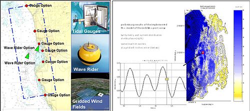
Components of the planned Coastal Monitoring System
|
Development of a Coastal Monitoring System for the Sustainable Environmental Planning of Jeddah Coastline, Saudi Arabia
German coordinator: Prof. Dr. Roberto Mayerle
Saudi coordinator: Dr. Abdullah M. Al-Subhi
German Scientist: Dr. Karl-H. Runte, Dr. Klaus Ricklefs, Dr. Peter Weppen, Dr. Karl-J. Hesse, Dr. Norbert Ladwig, Dr. Talal Etri
Saudi scientists: Dr. Khalid M. Zubier, Prof. Adnan J. Salama, Dr. Mohammed S. A. Mudarris, Dr. Adnan J. Turki, Dr. Hassan A. Jastaniah
This project focuses on the development of a Coastal Monitoring System (CMS), which will serve as a strategic platform for enhancing the sustainable environmental planning of Jeddah coastal areas. The CMS is going to help decision making by improving the understanding of the dynamics of the coastal area. It aims at supporting strategic decisions in the fields of pollution, aquaculture, ship traffic, contingency planning, coastal construction and climate changes. The CMS will be user friendly and embed data bases and dedicated process-based models for simulation of currents, waves and water quality. Specially designed field measurements with a dense spatial and temporal coverage will be carried out to provide the required data for the development of the process-based models. Training courses on the use of advanced measuring devices for coastal areas, on development and application of process-based models applied to coastal areas as well as on the use of the CMS to support decision making will be delivered in Kiel and Jeddah. MSc and PhD students from the Faculty of Marine Sciences (FMS) at King Abdulaziz University (KAU) are also welcome to join the International Programs in Coastal Geosciences and Engineering at the University of Kiel. Thesis topics related to the research project will be offered.

Scientific goals
The project aims at developing a coastal monitoring system to support the sustainable environmental planning of the coastal areas near Jeddah, Saudi Arabia. Focus will be given to the most relevant coastal concerns and problems related to hydrodynamics and water quality, such as sewage pollution from the domestic and industrial activities of Jeddah city, oil spills and climate change. The coastal monitoring system will integrate in-situ measurements, advanced remote sensing strategies, geographical information system (GIS) and numerical models, which will be embedded into a decision support system (DSS). The process-based models for prediction of flow, waves and water quality parameters will be set up, calibrated and validated using remote sensing information and field data. The CMS will also be applied to classify the coast in relation to morphological conditions, flushing and levels of nutrient pollution. The CMS will facilitate the identification of the most adequate coastal uses and enable the identification of the extent of coastal vulnerability with respect to climate changes and extreme events.
Project Components
The project design comprises the following modules:
-
Identification of available information: The existing physical information on the study area and gaps of information will be identified. This includes information from monitoring stations and in-situ measurement data (wind, water levels, current velocities, waves, sea bed sediments and suspended sediment concentration, parameters of water quality, coastal evolution and bathymetrical maps covering several years). Further data such as processed aerial and satellite images and bathymetry (e.g. based on laser technology) will be evaluated. The collected data will be implemented into a GIS database for further processing.
-
Operational System: A network of acoustic tidal gauges, meteorological sensors and a wave rider system providing continuous information on hydrodynamics and wind conditions will be set up. Data will be transferred telemetrically and processed in a CMS-Data Centre at the campus to be applied for running the numerical models.
-
Field Measurement Campaigns: Two specially designed field measurement campaigns with a dense spatial and temporal coverage over a period of two weeks will be carried out. The aim is to provide the data required for the development of the process-based models. This includes measurements of physical water properties such as salinity and temperature, current velocities, suspended matter, nutrient and oxygen levels and selected sediment parameters. A bathymetric survey is envisaged for the most relevant coastal areas. Measurements to identify the point and diffuse sources of nutrient pollution will also be carried out.
-
Numerical Models: Process-based models for simulation of flow, waves and water quality (dispersion of nitrogen and phosphorus compounds) will be developed and applied. The system will be set up, calibrated and validated using remote sensing and field measurement data. Simulation runs will be conducted to improve the understanding of the dynamics of the coastal area as well as to identify and handle the most relevant coastal issues for sustainable environmental development.
|